Typhoon "White Deer" will affect the precipitation process in the northwest and northeast of South China and other places.
BEIJING, Aug. 24 (Xinhua) According to the website of the Central Meteorological Observatory, from 24th to 26th, due to the influence of typhoon Bailu, there was moderate to heavy rain in southeastern Zhejiang and most parts of Fujian, heavy rain or heavy rain in parts of eastern coastal and southern Fujian and southwestern Jiangxi, and heavy rain in northern Guangdong and eastern Taiwan Province Island. However, due to the influence of high-altitude trough and low vortex shear, there are precipitation processes in the central and eastern parts of northwest China and northeast China.
Yesterday, heavy rain or rainstorm occurred in parts of the western Sichuan Basin and southern Sichuan, most of Yunnan, southeastern Guizhou, western Guangxi, northeastern Guangdong and Leizhou Peninsula, northeastern Zhejiang, northeastern and southern Hainan Island, and eastern Heilongjiang, with local rainstorms (100-133 mm) in Mianyang, Ya ‘an, Sichuan, Pu ‘er, Hechi, Guangxi and Sanya, Hainan; The maximum hourly rainfall is 50 ~ 89mm. There was moderate rain in the southeast of Wenchuan County, Aba Prefecture, Sichuan Province, with rainfall of 12 ~ 20mm in Yinxing Township, Gengda Town, Shuimo Town, Yingxiu Town and Xuankou Town.
Typhoon "White Deer" will affect South China and other places.
The center of the 11th typhoon "White Deer" (a strong tropical storm) this year is located at 5 o’clock this morning (24th) in the sea of bashi channel, about 200 kilometers south-east of Taiwan Province, China, which is 21.1 degrees north latitude and 122.6 degrees east longitude. The maximum wind force near the center is 11 (30m/s), and the lowest pressure in the center is 980 hectopascals, with a seven-level wind circle.
It is estimated that "White Deer" will move to the north-north direction at a speed of 25-30 kilometers per hour, and its intensity will be maintained or slightly enhanced. It will land or brush the southeast coast of Taiwan Province Island around noon on the 24th (11-12, 30-33 m/s, strong tropical storm or typhoon level), then move into the Taiwan Province Strait, and land again in the coastal area from Jinjiang, Fujian to Huilai, Guangdong from the night of the 24th to the morning of the 25th. The Central Meteorological Observatory continued to issue a yellow typhoon warning at 6 o’clock on August 24.
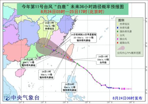
Gale forecast: From 8: 00 on the 24th to 8: 00 on the 25th, there will be 6-8 winds in the northeastern South China Sea, bashi channel, Taiwan Province Strait, the east of Taiwan Province, the southern part of the East China Sea, the waters near Diaoyu Island, the coast of Taiwan Province Island, the coast of Fujian and the eastern coast of Guangdong, and the winds in some sea areas or areas can reach 9-10, while the winds in the nearby sea areas or areas where the "White Deer" center passes are 11-12, and the gusts can reach 11.
Affected by typhoon "White Deer", from 24th to 26th, there were moderate to heavy rains in southeastern Zhejiang, most of Fujian, southwestern Jiangxi, most of Hunan, eastern Guizhou, Guangdong, most of Guangxi, Hainan Island and Taiwan Province Island, and there were heavy rains or heavy rains in parts of eastern coastal and southern Fujian, southwestern Jiangxi, western and southern Hunan, north-central Guangdong, northeastern Guangxi and Taiwan Province Island, and there were heavy rains in northern Guangdong and eastern Taiwan Province Island.
There are precipitation processes in the central and eastern parts of northwest China and northeast China.
Affected by the high-altitude trough and low vortex shear, there will be moderate to heavy rain in parts of central and eastern northwest China, western and southern North China, most of Northeast China, southern Huanghuai and northern Jianghuai in the next three days, with local heavy rain or heavy rain.
It is estimated that there will be heavy rain or rainstorm in parts of eastern and southern Fujian, southeastern Zhejiang, northeastern Guangdong and Taiwan Province Island from 8: 00 on August 24 to 8: 00 on August 25, among which there will be heavy rain or extremely heavy rain (250-270 mm) in local areas of southeastern Fujian, northeastern Guangdong and eastern and southern Taiwan Province Island. In addition, there is heavy rain or rainstorm in parts of central Shanxi, southeastern Sichuan Basin and southwestern Yunnan. The above-mentioned areas are accompanied by strong convective weather such as short-term heavy precipitation, thunderstorms and strong winds. The maximum hourly rainfall is 20 ~ 50 mm, and the local area can exceed 60 mm. To this end, the Central Meteorological Observatory issued a blue rainstorm warning at 6 o’clock on August 24.
The hot weather in Jianghan Jiangnan and other places continues.
In the next two days, there will be hot weather in the eastern part of southwest China, Jiangnan, Jianghan and South China. The Central Meteorological Observatory continued to issue a high-temperature yellow warning at 6 o’clock on August 24. It is estimated that there will be high temperature above 35℃ in most parts of the south of the Yangtze River, most parts of South China, eastern part of Southwest China, south-central Jianghan, western Jianghuai and other places during the day on August 24th, among which the highest temperature in most parts of Hunan, most parts of Jiangxi, northwestern Fujian, eastern Sichuan Basin, eastern Guizhou, northwestern Guangxi, northern Guangdong and other places can reach 37 ~ 39℃, and the local temperature can reach above 40℃.
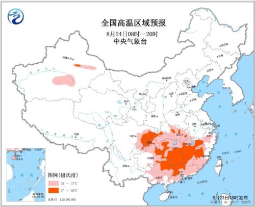
National forecast map of high temperature falling area
Specific forecast for the next three days
From 8: 00 on August 24 to 8: 00 on August 25, there were heavy rains or rainstorms in parts of eastern and southern Fujian, southeastern Zhejiang, northeastern Guangdong and Taiwan Province Island, among which there were heavy rains or extremely heavy rains (250-270 mm) in local areas of southeastern Fujian, northeastern Guangdong and eastern and southern Taiwan Province Island. In addition, there is heavy rain or rainstorm in parts of central Shanxi, southeastern Sichuan Basin and southwestern Yunnan. There are 7 ~ 8 winds and above in parts of eastern Xinjiang. There will be strong winds of 8-10 grades and gusts of 11-12 grades in the southwestern part of the East China Sea, the Taiwan Province Strait, the east of Taiwan Province, bashi channel, and the east China Sea northeast of the South China Sea. Among them, the winds in the nearby waters passing by the "White Deer" center can reach 11-12 grades and gusts of 13-14 grades.
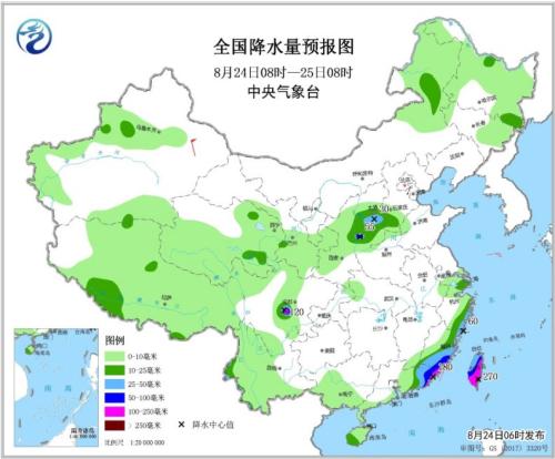
National Precipitation Forecast Chart (08: 00 August 24-08: 00 August 25)
From 8: 00 on August 25 to 8: 00 on August 26, there were heavy rains in parts of western Jilin, northeastern Qinghai, central Gansu, central Ningxia, southern Jiangnan, north-central and southern South China. Among them, there were heavy rains in parts of southern Hunan, southwestern Jiangxi, northeastern Guangxi, central and northern Guangdong, and local heavy rains (250-300 mm) in southern Jiangxi and northern Guangdong. There are 5 ~ 7 winds and above in parts of southern Jiangxi, north-central Guangdong and eastern Xinjiang. There will be strong winds of 7-8 grades and gusts of 9 grades in the Taiwan Province Strait and the northeastern South China Sea, with winds of 9 grades and gusts of 10 grades in parts of the Taiwan Province Strait.
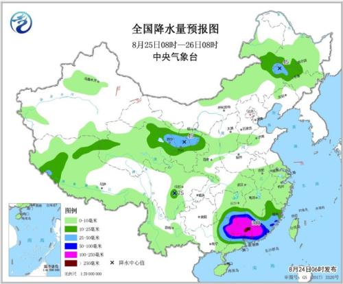
National Precipitation Forecast Chart (08: 00 August 25-08: 00 August 26)
From 8: 00 on August 26 to 8: 00 on August 27, there were heavy rains in parts of eastern Inner Mongolia, north-central Northeast China, eastern Northwest China, southern Huanghuai, northern Jianghuai, western Jiangnan, southwestern Sichuan Basin, southeastern Southwest China and northwestern Guangxi. Among them, there were heavy rains (100-130 mm) in northeastern Inner Mongolia, northern Anhui, southern Hunan and northeastern Guangxi. There are 5 ~ 6 winds and above in parts of western Hunan and northwestern Guangxi.

National Precipitation Forecast Chart (08: 00 August 26-08: 00 August 27)