Central Meteorological Observatory: The temperature will continue to be low in most parts of China, with rain and snow in the south.
CCTV News:The Central Meteorological Observatory issued a weather bulletin. During the day, there was snowfall in Yantai and Weihai, Shandong Province. In the next three days, the national temperature will continue to be low, paying attention to the impact of strong cold air on the central and eastern regions from the 18th to 20th. The high altitude areas in western Guizhou pay attention to the icing effect of freezing rain on transmission lines, wind farm fans and other facilities. China’s offshore waters are windy, and we are concerned about the harm of strong winds at sea.
First, the weather situation
Snowfall weather in Yantai and Weihai, Shandong Province;During the day, there were small to medium snows in Yantai and Weihai, Shandong Province, and there was a local snowstorm in Yantai, with a precipitation of 12 mm; There is freezing rain in the western part of Guizhou. There are 6 ~ 8 gusts in Fujian and Zhejiang coastal areas, and the local level is 9 ~ 11.
Second, the key weather forecast
1. The temperature will continue to be low in most parts of China.
In the coming week, the temperature in most parts of China will continue to be low. It is estimated that from 20: 00 on December 17 to 20: 00 on December 20, the daily minimum temperature in parts of northern Xinjiang, central and eastern Northwest China, Inner Mongolia, North China, Northeast China, Huanghuai, Jianghuai, Jianghan, northern Jiangnan and Guizhou will be more than 5℃ lower than the historical period, and the daily minimum temperature in parts of eastern Northwest China, Inner Mongolia, North China, Northeast China, central and eastern Huanghuai and eastern Jianghuai will be 7℃ lower than the historical period.centreThe Meteorological Observatory continued to issue a low-temperature yellow warning at 18: 00 on December 17.
In addition, from 20: 00 on December 17 to 20: 00 on the 18 th, there will be strong winds of 5~6 and gusts of 7~8 in southern Xinjiang, central and northern Tibet, central and western Inner Mongolia and Hexi, Gansu; There will be strong winds of magnitude 7-8 and gusts of magnitude 9 in the southwestern part of the East China Sea, the Taiwan Province Strait, the bashi channel, and the northern and central parts of the South China Sea, with winds of magnitude 9 and gusts of magnitude 10 in some parts of the central and eastern South China Sea (see Figure 3).The Central Meteorological Observatory at 18: 00 on December 17Continue to issue a gale blue warning.
It is estimated that from 18th to 20th, a new strong cold air will affect the central and eastern regions from north to south, and the temperature will drop by 4 ~ 8℃ in parts of central and western Inner Mongolia, eastern Northwest China, North China, Huanghuai, Jianghuai, eastern Jiangnan and central and eastern South China, and the temperature will drop by more than 10℃ in parts of northwestern Shanxi, eastern Liaoning and eastern Jilin.
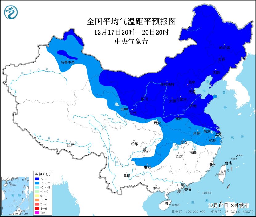
Figure 1 Forecast chart of national average temperature anomaly (from 20: 00 on December 17 to 20: 00 on December 20)
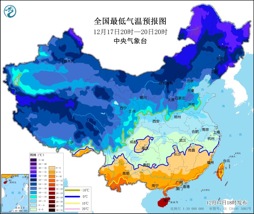
Figure 2 National lowest temperature forecast map (20: 00 on December 17 -20: 00 on December 20)
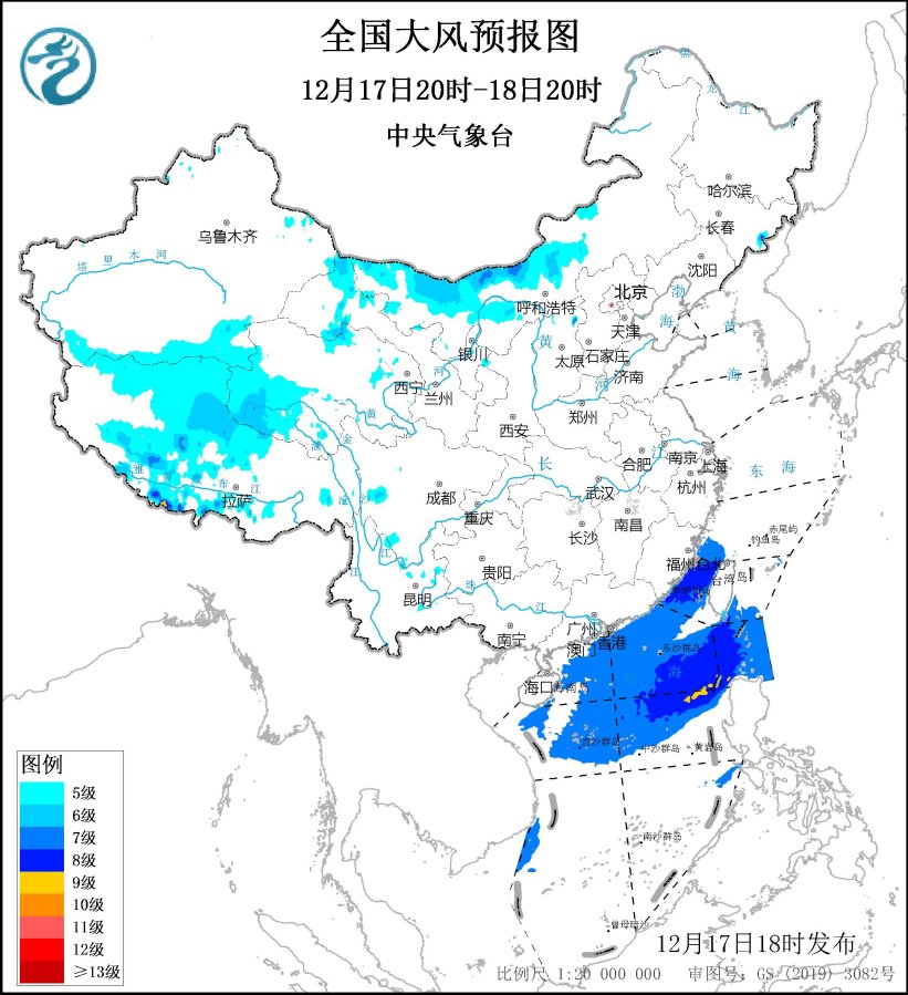
Figure 3 National Gale Forecast Chart (20: 00 on December 17th-20: 00 on December 18th)
There is rain and snow in the south.
From the night of 17th to 19th, there will be rain and snow in most parts of the south, sleet or snow in some areas such as Jianghuai area, light rain and local rain in Jiangnan and South China. From the night of 17th to 18th, there was freezing rain in high altitude areas such as north-central and eastern Guizhou, western and southern Hunan.
Third, the specific forecast for the next three days
From 20: 00 on December 17 to 20: 00 on December 18,There is light snow or sleet in parts of southeastern Tibet, southern Qinghai, southeastern Northwest China, western Huanghuai, northern Sichuan Plateau, Jianghuai and Jianghan, among which there is moderate to heavy snow (5 ~ 7 mm) in parts of southeastern Tibet, north-central Anhui and north-central Jiangsu. There are small to moderate rains in parts of the eastern part of Southwest China, the central, eastern and southern parts of Jiangnan, northern South China, Hainan Island and Taiwan Province Island. There are 4 ~ 6 winds in parts of central and western Inner Mongolia, Hexi in Gansu, Liaodong Peninsula and central Zhejiang, and there are 7 ~ 8 winds locally (see Figure 4).

Figure 4 National Precipitation Forecast Chart (from 20: 00 on December 17th to 20: 00 on December 18th)
From 20: 00 on December 18 to 20: 00 on December 19,There is light snow or sleet in parts of central and eastern Liaoning, southeastern Jilin, central and southern Jiangsu and Anhui, western Jiangxi, northeastern Hunan and central and eastern Guizhou, among which there is moderate to heavy snow (5 ~ 6 mm) in central Liaoning and other places. There is light rain in parts of south-central Jiangnan, southern Guizhou, western and northern Fujian, most of Guangxi and Hainan Island. There are 5 ~ 6 winds in parts of Liaodong Peninsula, northern Hebei, Shandong Peninsula and northern Zhejiang (see Figure 5).
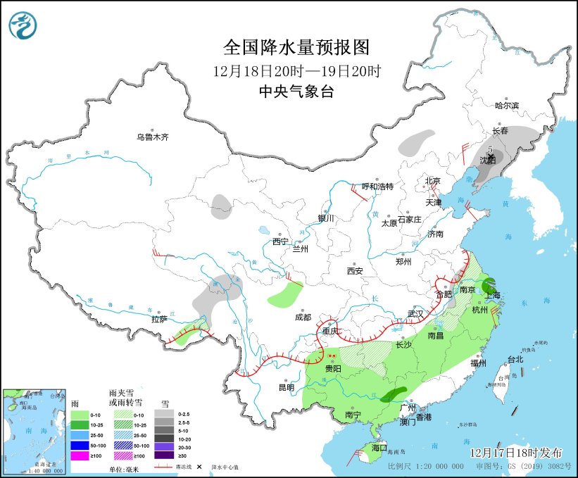
Figure 5 National Precipitation Forecast Chart (20: 00 on December 18th-20: 00 on December 19th)
From 20: 00 on December 19 to 20: 00 on December 20,There is light snow in parts of Ili Valley in Xinjiang, eastern Jilin and Shandong Peninsula. There is light rain in most parts of Zhejiang, Fujian, southwestern Guizhou, central, eastern and southwestern Yunnan, southeastern Guangxi, southwestern Guangdong, and northwestern Hainan Island. There are 5 ~ 6 winds in parts of Liaodong Peninsula, northern Hebei, Shandong Peninsula, northern Zhejiang and southeastern Guangxi (see Figure 6).
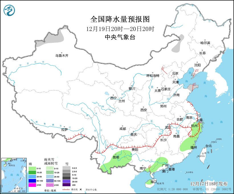
Figure 6 National Precipitation Forecast Chart (20: 00 on December 19 -20: 00 on December 20)